There's a lot of talk out in the world about the PCT (Pacific Crest Trail) after Cheryl Strayed's book Wild was turned into a movie starring Reese Witherspoon. But those in the ultrarunning and backpacking worlds have waxed poetic over those 3 little words for decades. I myself absolutely loved the movie The Runner about David Horton setting a speed record on the trail's entire length. For all the cool places I've run, I hadn't made it on a single inch of this 2,650 mile trail that runs from Mexico to Canada. I had been on my first fastpacking trip last year (28 miles over 4 12,000 foot high passes of the Four-Pass Loop in the Maroon Bells outside Aspen, CO in 2 days) and while it was hard, I had so much fun. So I wanted to do another trip this year and the weekend of July 14 was looking like my last shot before a busy second half of the summer (producing Rough Creek Trail Run on September 17!), and after I had gotten my health back on track from a series of issues in May and June. I was enamored with pictures of the Three Sisters mountain area of Central Oregon, between Bend and Eugene. My only real exposure to Oregon had been the north side of the state (Seaside, Portland, Mt. Hood, and the Columbia River Gorge).
What ended up happening was 9 1/2 hours on my feet, covering 21 miles of challenges and 4200 feet of elevation gain/loss. That's 200 feet of gain and loss per mile!! Talk about a workout! Now the nitty gritty because the important stuff is really in the details....


The loop around the Three Sisters (which includes 15 miles of PCT that were open) wasn't open yet for this trip. It would have been fun, but there were still a couple sections up high with too much snow and one section where the tree blowdown was so bad that the Park Ranger said that someone had been out there the Sunday before my trip now that enough snow had melted and encountered 150 trees in only a half-mile. So scratch that. Here I had been thinking that watching the snowmelt reports that I was in decent timing - glad I called.
I thought I would do an out-and-back then on just the PCT. I mean, it's the PCT...
I didn't really know what I was going to encounter with the snow still melting off and the mosquitoes getting worse (but supposedly not HIGH season quite yet) and I didn't know the region or terrain. Don't get me wrong - I wasn't unprepared; I had my map and had studied it and downloaded section by section details on the PCT by mile from a website. But subjective narratives and the current year's conditions vs previous made a lot of details fuzzy. I was most nervous about the snow levels (I have basically no snow experience at all) and about the mosquitoes (I am always that person who gets the most bites outside in a crowd, I'm just susceptible to getting bit, and I have a bad histamine reaction too so the bites swell up big). So I was anxious about this adventure.
I arrived Wednesday night to Sisters, OR and stayed in a hotel so I could get a good night's sleep and leave at 5:45 am to head to Camp Lava Lake Trailhead. This would put me at mile 1980 on the PCT. I had already decided to head south.

My pack weighed in at a svelte 18 pounds, excluding water. That covered my tent, sleeping bag, extra clothes, emergency gear, and food. I had everything planned around having 2 days available to hike what I wanted. I was really proud of how carefully I had planned out what to bring and managed to eliminate about 7 lbs from last year's adventure.
At 6:30 am I left the trailhead after filling out the required wilderness permit, putting a copy in the box and stowing the copy (as required) in my pack.

18 pounds is certainly a load but compared to the 23-25 lbs I had carried last year, it felt so much lighter. I was bit once in the parking lot filling out the permit but the mosquitoes at dawn weren't bad.
I hiked through beautiful forest with soft soil and roots crossing the trail. I knew there would be a lot of climbing early on so I tried to just keep a good pace. Since I don't do great with altitude, and the bottom of the course at the start was a mile high in elevation, it took me about an hour to feel comfortable with my breathing.

 |
| I love the shadow of the forest on my left across the lava field on my right in the dawn hours! |
I passed a couple ponds like this one....

and both North then South Mathieu Lakes...

 |
| North Mathieu Lake |
They were just stunning in the early morning with wisps of fog hanging over the water, but I took my pictures quickly as I only saw a couple people camping at the designated campsites and the mosquitoes had chosen me as their breakfast.


Then through a volcanic area for a while. I wasn't expecting so much lava rock on this section of the PCT so that was pretty cool. Although later all that rock would start to make my feet pretty resentful. And then at mile 3 I was eating my first food, these EPIC bar bites. It's basically like a moistened meat bar broken into bites (this one bacon-based). Well the last couple bits went down the wrong pipe and .... Oh no.... I was hacking and coughing and my throat hurt and each cough now had a burp like my body really really wanted me to just throw it all up. I put my foot down - NO! I have planned my calories around keeping in this high-carb pastry I ate on the drive to the trailhead and the earth can not have it!!!
This would lead to a sore throat all day which impacted my interest in eating, although I would continue to get calories. So I had my (first) moment of "okay, so things happen!"


Lots of loose lava rock in the lava field areas. Amazing terrain to walk through.
I went around a feature called Yoapah's Crater which seemed to be just a giant dome of lava ash. Interesting geologic feature in the middle of it all. Very different than the rest of the terrain on this hike!

At mile 5 after that bit of lava stuff I came out to a beautiful alpine meadow with a stream. Just gorgeous.
 |
| Intersection with Scott Trail |
And yippee for water as my 20 oz handheld was ready to be refilled. As I pulled out my Steripen to purify the water and knelt to fill up my handheld in the stream, the mosquitoes were all over me. Stupid alpine meadow! And then before I knew it, the Steripen is blinking red. What?! It hasn't done this before. All I know is red is bad and means all the germs are still there. I try and retry. Later on, after I was back in civilization, a quick googling confirmed stupid human error - between the sun hitting the indicator making me not see the green light go off originally I had then messed up the order of press-first-then-insert-in-
Fine, I've never used iodine tablets before - this is as good a day to learn as any. So I pulled out my 1 Liter Platypus bladder, used my handheld to collect the water to fill it, and then went through the protocol on the iodine tablet container. I would now have no water for 33 minutes (30 to treat and then 3 minutes for the followup tablets to remove some of the nasty taste and color - super happy with the result). So that was going to be the day, huh? Scrambling to collect and treat water amid a swarm of mosquitoes and then going waterless for 30 minutes. Gotcha. I even reached up under my cap brim and squished a mosquito in the edge of my hair at my temple. Gross. So at home I need to practice sterilizing with the Steripen out in the sun 10 times over so even under high stress I don't goof it up.
The next section had 3 miles of lots of lava and snow and moonscape-like terrain.

It was a climb up gradually to Opie Dilldock pass (6900'). Which included an uphill swarth through a lava slope covered in icy snow, which rattled me a little since I am not "one" with the snow.... Or with balance.
 |
| Those are footsteps cutting from the middle of the field on the left side and going diagonally up the slope to the right edge of the picture. Each time my foot slid I would tense up and freeze. You could see that some hikers going northbound had just decided to slide down the slope when coming the opposite direction. |
 |
| Mount Washington to the north in the distance on the far right. My trail on the far left. |
 |
| Top of Dilldock Pass. It's like I'm on the moon! |
 |
| ALL the rocky gravel. Blech. |
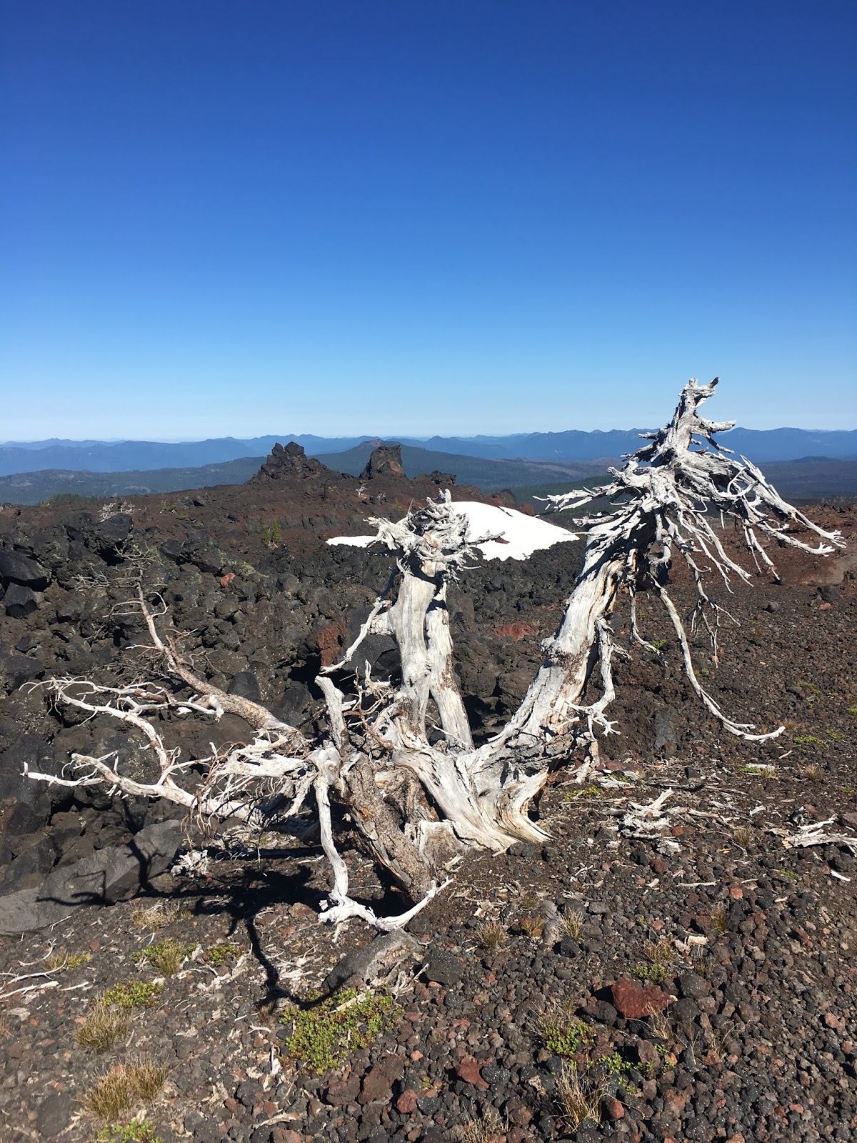 |
| This warped tree just made the terrain seem even more other worldly! |
After the pass, there were about 10 short switchbacks in the lava heading downhill. Tromping through more gravely lava rocks, I finally got back to forest soil, which felt so much better on my feet.
 |
| Even with mosquitoes everywhere, I can still find my smile! It's still my happy place! |
I had an instance here where I was thankful for the app on my phone. "Halfmile's PCT" is super useful. It tells you about upcoming trailheads and landmarks but also springs and campsites. And it has a diagram mode that shows your GPS location on top of a GPS map of the trail (no topography under, just the trail). I hit a sudden fork in the trail and some footsteps went across a snowfield. The other way seemed to dead-end a little ahead. So I cross the snowfield and then couldn't find where the trail goes. I stared at a wall of snow on lava and a stream coming out from it. Thanks to the app I headed west and found where the stream was basically the trail until the stream disappeared under the ice and the trail continued.
 |
| Where's the trail?! |
The first 8 miles I had only encountered 2 thru-hikers heading northbound. One, maybe about 70 years old, had started in Mexico the previous summer and made it to Etna in California and had picked up there this summer. Another guy, mid-30s, was thru-hiking but had just finished a 4 day stay over in Bend. The impression I had was that thru-hikers treated coming across each other as a chance for a quick chat - where you coming from? Where you going to? Where'd you start the day? How's it going? Friendly and more than I expected. At mile 8, I had my first (and only) southbound hiker. Sam was from Atlanta, GA and friendly. We chatted for a couple minutes and then I fell in behind him as his pace was a little faster than me. He had also done the Maroon Bells and also wore Brooks Cascadia shoes like me! He was telling me how his were already falling apart (yes, I informed him, the uppers fall apart in the 10's. Never had a problem in the 9's!) and we talked about my hike plans and his. We hung together for almost a mile when I told him I couldn't keep his quick pace and wished him luck.

Mile 9 found me in the Obsidian special entry area. You were allowed to hike through without a permit if you entered via the PCT and stayed on the PCT, but you couldn't camp in the area. I was hitting snowfield after snowfield now. Some of which were 200 feet long. Like I would follow the footsteps and start tromping, occasionally sliding, and couldn't see where the snowfield ended. Crazy.


I made it to Glacier Creek and it was time to sterilize water again. And be attacked by a million mosquitoes. I was really tiring of this. It meant that I could never ever take a break or I would be set upon by these varmints. Part of the fun of being in such a pretty place in nature was to get to just sit on a rock or a log or in the alpine meadow and just relax, get the pack off, rest your feet, and enjoy the scenery. This is what I expected because this is what the fastpacking trip last year was. Instead, I had been on my feet all day and any stop was leading to more bites. I was getting highly frustrated.
A half mile after Glacier Creek, I said "THAT'S IT! I've had it." I'd been on the go for 4 1/2 hours straight. I was not in the mood with being eaten alive that evening as I set up my camp, and having to be zipped up in my tent unable to enjoy the outdoors in the evening, and then equally getting bit up tearing down the next morning for another day of being on my feet all day. Not my idea of fun. And if they were this annoying so far, knowing they would get worse as it warmed up really worried me. I added on the lava rock time on my poor footsies, leg fatigue from the unsteady snowfields, and sitting out drinking for 30 minutes every couple hours, and I had been doing the math for a while. I could get back to my car at a reasonable late afternoon time if I kept up the same pace and extended my day from the originally planned 15-17 miles to a whopping 21 mile day.
The decision was made: There would be no camping and no feasts for the mosquitoes (well, no more than there had to be).
Turning around at 10.5 miles, I had ingested about 300 calories. I would eat another 300 going back. I was happy with the food I had brought (EPIC meat bites, shelled and salted pistachios, honey stinger waffles, and honey stinger protein bars) but I had to make myself eat since my sore throat from early morning bothered me most of the time out there.

Halfway on the return back, I reapplied the Off! Deep Woods bug spray, not that it was doing much good. And sunscreened my arms again. I was very careful each time I would pull my pack back on that I tugged down my shirt sleeves. In the very high altitude and full sun of my Maroon Bells trip, I had ended up with a small strip of second degree burn right where my shirt had inched up on one sleeve because of my pack. That was not going to happen again!
Climbing over Dilldock Pass was a lot harder going back northbound. It was shorter and steeper, and the gravelly lava hurt my already swelling feet.


My last few hours out there the wind picked up a little. I could try to time finding a rock or log in the shade with a windy gust and get maybe a minute and a half or rest for my feet before the wind would die back down and the bugs that had been struggling in the wind to reach me would attack. Grrrr.
The last couple hours I encountered what seemed to be more folks like myself - short distance or day hikers. The last 2 miles through the woods by the lakes was excruciating as mosquitoes had found my worst bite spots and would go after those areas over and over again. I was walking catnip (well, if mosquitoes were cats). And I would yelp with each new bite. So I ran as hard as I could and pulling 16 minute miles with an 18 lb pack is quite a run!
 |
| South Mathieu Lake in the daytime |
I was so thankful to see my car. It was 4 pm. I had been on my feet, with that pack heft, for 9 1/2 hours. How different that time would have felt with a break from the bugs to sit out in nature and rest my legs, right? I drove into town and got a room, showered, ate dinner, then had a Benadryl, applied cortisone cream, and slept.
The next morning, the heat and swelling was down a little on the bites so I could see the damage. As one example, on the back of my right leg is 14 bites. Just in that one area.
I guess long pants and long shirt would help, but with the smaller pack, I did jog many downhills at a trot. That wouldn't be very comfortable in pants. Besides the fact I overheat easily and the afternoon was warm, hitting 86 degrees with no clouds.
So I came at the wrong season for bugs. But in my life's schedule, it was the best season for me. So it comes down to, if we wait for perfect conditions, how long will we be waiting? Instead I made the best of it, had an adventure, took 72 pictures, traveled 21 miles of Pacific Crest Trail, and have new memories for it NOW rather than the potentially perfect condition that may or may not exist in a future year. And, even with 30 mosquito bites, that is always a win in my book! :-)


