Note that my coach's race plan for me is probably just "Run and finish" as he's not as specific about this stuff as me.
Miles 1 to 12
Course Description from Race Website:
"From the start near the shore of Spooner Lake the course follows the dirt, North Canyon Road for approximately 1 mile before it ventures onto the Marlette Trail. The Marlette Trail meanders through conifers and Aspen groves as it climbs approximately 1,500 feet before descending about ½ mile to the shore of tranquil Marlette Lake.
From Marlette Lake (7823 feet) you'll continue to climb on dirt roads to the Hobart Road aid station at 8120 feet.
After leaving the Hobart Road aid station the course climbs past Marlette Peak and Harlan Peak before descending to the Tunnel aid station at the junction of the Tahoe Rim Trail and the Tunnel Creek Road."

The Plan: Just hang out. There's going to be some pretty good climb - 1500 ft to the first aid station at mile 6. Take it easy, line up in the back, don't force yourself to go the speed of those around you in the line of powerhikers up the hill.
Aid Stations: Miles 6, 11.5
Miles 12 to 17
Course Description:
"After departing from Tunnel Creek aid station the course makes an approximate 6.3-mile loop to Red House aid station and back (with a significant climb near the end of the loop)."
We hit the Tunnel Creek aid station at the beginning and end of this loop. In fact, the Tunnel Creek aid station gets hit 3 times in this one interesting single loop 50 mile course.
I've read things about the legendary Tahoe kitty litter sand, creek crossings (?), and mud in this section.

The Plan: Mile 15-19 is usually an unhappy place and there's a pretty good climb mile 16, so just take it so and fight those mental demons.
Aid Stations: Mile 17 (volunteers often set up an unofficial aid station at Red House but not official)
Miles 17 to 30
Course Description: "Upon returning to the Tunnel Creek aid station the 50M/100M course will travel approximately 6-miles north along single track section of the Tahoe Rim Trail. This section is mostly rolling with breath-taking views of both Lake Tahoe and the Washoe Valley. At the Incline Creek trail junction the course drops down towards Incline Village, offering spectacular views of the North Shore of Lake Tahoe. This new section of the course will provide views of Lake Tahoe not many but locals have seen. The Incline Creek trail will plunge down the mountain for approximately four miles and a loss of 2,000 feet of elevation, following the creek with many dives including twists and turns. As the trail flattens out towards the bottom you will come into the Tyrolean Village area directly behind homes. 100 Milers on your second pass in the middle of the night or early in the morning please be respectful of the residents there and keep the chatter to a minimum until you clear this area. Once you come to the pavement it is just a short ¼ mile to the Diamond Peak Lodge parking lot area. Proceed to the lodge where the aid station will be. This will be the 30 mile and 80 mile aid stations."

The Plan: Fight through that mental bad place miles 15-19 usually is and get through the gradual uphill to Bull Wheel, remembering there's a great fun "Wheeeeeeee!!!" of a downhill on the other side of it. This is a two-way traffic section between Tunnel Creek and Bull Wheel too, that we hit coming back at miles 32-35. I should hit the top 10 50-milers, so count them off and wish them a "good job".
Miles 20-21 are typically my best in any distance race, so take advantage of it. But not from a viewpoint of busting my quads, more as a chance to get some faster pace while enjoying a recovery with the lower heart rate. If my heart rate is staying up, I'm killing my quads and that's not the goal here.
I would like to come into mile 30 around 3:35 pm (9 hr 35 min into the race)
Aid Stations: Miles 20.5, 30. This is the biggest stretch without aid, 9 miles, so fill up the hydration pack at Bull Wheel. I've heard Bull Wheel is bare bones and really just water, so if I need to throw some food into my pack at Tunnel Creek, it wouldn't hurt. A couple cookies fit in that front pocket of my Ultraspire Surge nicely. ;-)
Plan on taking honey stinger chews at mile 24 before the big downhill starts. My drop bag is at mile 30, so change socks if I absolutely have to (rain?), change shoes, and restock supplements.
Miles 30 to 34
Course Description: "From there the course will follow the dirt service road up the ski run and onto the Crystal Ridge ski run up and over the top of Diamond Peak resort at 8540 feet for a 1700 foot climb in just under 2 miles. The course drops 50 meters down to the Bull Wheel aid station (water and typical aid station fair only. No hot food) on the Tahoe Rim Trail. The course then returns to the Tunnel Creek Aid Station 3 miles south. (Turn right on the TRT) The average elevation is between 8000 and 8800 feet dropping to a low at 6888 at the Diamond Peak Lodge."

The Plan: This uphill is what people dread and can kill your pace for the rest of the race. I've seen pictures but I know that won't prepare me for how big this uphill is, plus adding the altitude. Take it super slow. I get the impression from talking to coach that there are small landings that I should stop and breathe every 2nd or 3rd one on the way up. Just be comfortable hanging out going up this hill for an hour. I can't rush it. It will only make the next 20 miles awful. It will be about 3 pm and exposed, so... SUN.
After the hill, cruise back to Tunnel Creek. Just take it easy and recover from what I just went through. Slow run. Don't walk this - if I'm aching for a walk, I can do the walking on the uphill at mile 35!
Aid Stations: Miles 32, 34.5
Miles 34 to 43
Course Description: "From the Tunnel Creek aid station, the course will follow the Tahoe Rim Trail south towards the Spooner Summit trailhead passing both Marlette Peak and Snow Valley Peak (and visiting both the Hobart Road and Snow Valley Peak aid stations)."

The Plan: Tunnel Creek to Hobart is a two-way traffic stretch. I will be there in that section between about 10 1/2 to 13 hours in. This means coming the other way I'll see 100 Milers running 18-23 hours. This means I should encounter the top 10 or so finishers! Focus on that. Watch for them; count them off.
Aid Stations: Miles 40, 43. At mile 40, get my headlamp out of my pack. With the shade of trees, I may need it before I get to the Snow Valley (mile 43) aid station. Per coach Jeremy: "Thank the boy scouts!" (at mile 43)
Miles 43 to 50
Course Description: "From the Snow Valley Peak aid station the course makes about 5.4 mile descent before reaching the Spooner Trailhead aid station at Highway 50 and connecting with the Spooner Lake trail for the final 1.7 miles to the finish."
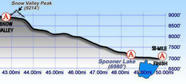
The Plan: Um, finish? One way or another. Just finish.
Aid Stations: Mile 48.5, unmanned.
This blog post is a big help in preparation for this year's 50 miler. By chance do you have the above race profile in one pic/jpeg/pdf or on a specific webpage. I'd love to see it all in one piece. Thanks!
ReplyDelete